

Services
We deliver end-to-end data infrastructure—from field collection to structured storage and seamless delivery. Whether you're syncing remote sensors, capturing field notes, or integrating historical datasets, we build reliable pipelines that move your data from source to insight.
Our team of database engineers and developers specialize in custom architectures that support both spatial and non-spatial data. We offer deployment and management of PostGIS for advanced geospatial analysis, NoSQL databases for flexible document storage, and Firebase for real-time mobile app integration. Need a centralized data lake for your research program or organization? We’ve got that covered, too.
From schema design to API integration, we ensure your data is accurate, accessible, and ready to power decisions. Let us build a solution that fits the way you work—secure, scalable, and future-proof.
Data


Custom Solutions
We thrive on solving complex, domain-specific challenges—it's what sets us apart, and why our clients love this service line. Whether you're collecting ecological field data, managing environmental sensor networks, or modeling coastal resilience scenarios, we can help automate and integrate the entire pipeline from data capture to delivery.
Need a custom-built software solution to streamline research workflows, visualize real-time data for stakeholders, or support conservation decision-making? We’ll design and deploy systems tailored exactly to your use case — secure, scalable, and stable.
Analytics
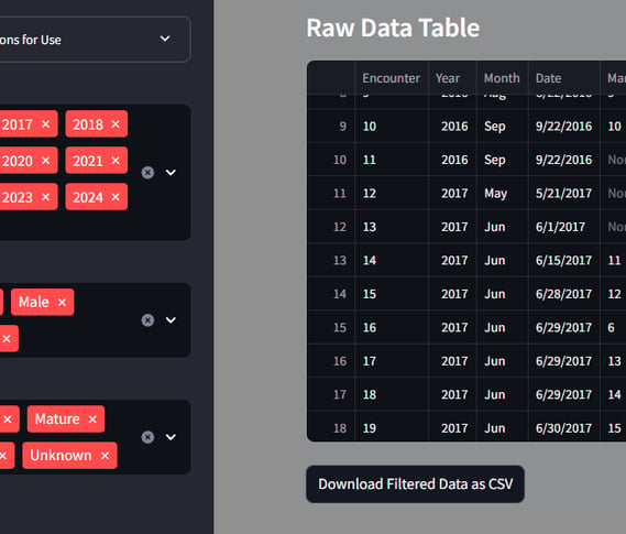
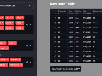
Our analytics services combine advanced statistical methods with clean, impactful data visualization. We specialize in designing and deploying custom dashboards tailored to your workflows—whether hosted in the cloud or integrated into your existing platforms. From exploratory data analysis to decision-ready insights, we help transform your data into clear, actionable narratives.


Habitat Monitoring
We deliver real-time ecological insight using advanced sensor networks, cloud-integrated data pipelines, and intuitive dashboards—putting meaningful metrics directly into your hands. Our team of experienced ecologists offers both pre-configured and fully custom monitoring solutions tailored to your use case, objectives, and long-term stewardship goals.
Whether you're meeting conservation compliance requirements, documenting habitat quality for land use planning, or supporting wildlife health and restoration efforts, we provide the tools and expertise to streamline the process. From field sampling to predictive analytics, we help you understand what's happening on the ground—today and over time.


Our FAA-certified and insured drone operators prioritize mission planning, safety, and regulatory compliance from takeoff to data delivery. We deploy both rotary and fixed-wing VTOL platforms equipped with a variety of sensors—including RGB, thermal, and hyperspectral—tailored to your project's specific needs.
From precision mapping and vegetation analysis to infrastructure inspection and thermal surveillance, our sUAS services offer high-resolution, cost-effective data collection at scale. We also support clients through preprocessing, data transformation, and the generation of GIS-ready products to ensure actionable, site-specific insights.
UAS Services
Self-Hosted SaaS


Our in-house servers are purpose-built for scientific performance and reliability. Whether your workloads demand high single-core speed (Intel Core Ultra 9) or scalable multithreaded power (AMD EPYC), we have you covered. We offer ultra-fast NVMe SSDs for active applications and mirrored enterprise-grade HDDs for long-term, secure data storage.
With modern GPUs (NVIDIA 40- and 50-series) on standby, we’re ready to accelerate complex analytics, model training, or visualization workflows. All systems are backed by intelligent power management, daily snapshots, and monitored uptime—so your tools stay available, fast, and mission-ready.
Focus on discovery, insight, and impact—we’ll handle the hosting.
Cloud Deployment and Migrations
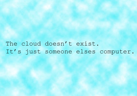
Let that other computer be ours. With certificate holders in AWS, GCP, and Microsoft...our cloud migration specialists can move your data into a cloud infrastructure designed for efficiency and optimized for your workflows.
We offer a wide range of cloud deployment services and would love to talk to you more about your current stack and what you see in the future. We also offer VPC hosting options on our stack.
EcoVision Analytics
Key West, FL
Bozeman, MT
305-647-4799 solutions@ecovisionanalytics.com